Above All - Ohio | Services | Verticals | True Verticals
| Obliques | Verticals | Video | Thermography | Aerial Lift | Construction | Architectural | Graphics |

| Near Verticals | True Verticals | Custom Photo Maps | Stock Photo Maps | Interactive & Geotagging |
|
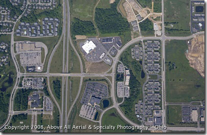
True verticals are aerial photos taken from a specially calibrated camera mounted in the belly of the airplane. This gives you a highly accurate, straight down perspective of a site or area. True verticals can either be a single photograph (called a "spot shot") or a series of 2 or more photos stitched together to form a seamless map of a large area (see the Custom Photo Maps or Stock Photo Maps sections for more information). By stitching together geo-rectified, true vertical images, entire cities and regions can be photographed and mapped with a great degree of accuracy and detail. True verticals can be printed to scale and measurements can be taken directly from the photographs. True verticals can also be imported into CAD and other engineering programs. True verticals can be flown at whatever altitude is required to meet your specific needs. Higher altitudes cover more area with fewer pictures (thus reducing the overal cost) while lower altitudes allow for acquisition of very high resolution images. We have the capability of performing complete aerial surveys with GIS data (including land elevations) embedded into the imagery if needed, but true vertical imagery can be provided without it. As with our other services, our true vertical assigments are customized to our individual clients' exact needs. We will work hard for you and with you in order to find the "sweet spot" between your resolution and information needs and your budgeting reality! Let us know how we can help with your project! |

|
Above All Aerial & Specialty Photography - OhioOur images will work for you.℠ |

