
Click-to-call us:
Medina | Akron, OH
330-441-4916
Cleveland, OH
216-619-7979
Columbus, OH
614-358-2772
Pittsburgh, PA
412-223-9001
Toll Free Phone
877-AIR-PIX-6
(877-247-7496)
Toll Free Fax
877-AIR-PIX-5
(877-247-7495)
Above All - Ohio | Services | Infrared | Deer & Wildlife Surveys
| Obliques | Verticals | Video | Thermography | Aerial Lift | Construction | Architectural | Graphics |

| Infrared | Roofing | Wildlife | Mechanical | Electrical | Building | R & D | Analysis & Reporting |
|
Above All - Ohio is one of the few companies in the nation that can complete aerial infrared deer (or other wildlife) surveys 100% in-house. We have our own aircraft, our own state-of-the-art, high-resolution infrared camera, our own professional pilots, and our own certified thermographer. With no need to outsource any part of the job, we can offer very competitive rates and 100% ownership of the project from start to finish. Many states (including Ohio) require a deer study to be performed prior to creating plans to cull the herd. Culling is necessary when the deer population grows too large, becoming a nuisance or even a safety or health hazard to towns and cities. If you are involved in considering or planning a wildlife control program of any kind, please give us a call - we will be happy to provide you with more information and a free, no obligation quote. Winter is the best time of the year to get accurate deer counts and aerial infrared surveys are the fastest, most accurate, and most cost effective way to get counts in large areas. When the leaves come off of the trees and the air gets cold, the deer show up like bright lights on our infrared camera. Click through the photos below for a ground-based IR wildlife imaging demonstration. How many deer do you see in the visible image? If you're really sharp, you might see one - right in the middle of the frame. Click "Next" to see the IR image and watch four deer "magically" appear. The third image points out the deer (although, it's pretty obvious where they are in the second photo, too...). To demonstrate the sensitivity and resolution of our camera, the final image points out three tiny birds that are clearly visible in the infrared image but are essentialy invisible to the naked eye. (Note: The images below are not full resolution images.) |
|
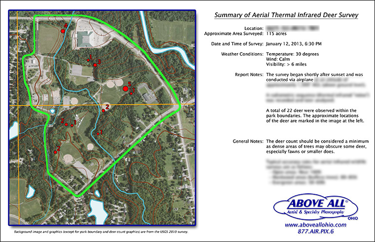
Below is a sample of a deer survey summary report. We provide this type of report for all jobs along with a more detailed written report of our findings. Every report is customized to your specific situation and needs. We can mark the locations of wildlife on stock photomaps (such as USDA or USGS imagery as shown), your existing imagery, regular maps, or custom photomaps that we can create for you.
|
|
Please contact us and we will be happy to provide a quote for your aerial infrared wildlife survey. As a reminder, we offer this service nationwide, not just in our home state of Ohio! |
Above All Aerial & Specialty Photography - OhioOur images will work for you.℠ |
