Above All - Ohio | Stock Photo of the Week Archive | 2013

|
2012: Archive | Slide Show |
2013: Archive | Slide Show |

2014: Archive | Slide Show |

|
|
|
|||||
|
|||||
|
|
|||||
|
Our photos look best when viewed on a properly calibrated monitor. While not a true calibration, a quick and easy way to get close is to adjust your monitor until you can see all eleven (11) distinct shades of gray in the image below. 
|
|||||
|
|
|
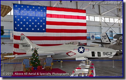
December 16-31, 2013
"MAPS Museum" The Grumman F-9F Cougar displayed here under a giant American flag is just one of the many fully restored miltary aircraft you can see at the MAPS Air Museum, which is located on the west side of the Akron-Canton Regional Airport in North Canton, Ohio. "MAPS" stands for Military Aviation Preservation Society and it is a mostly volunteer, non-profit organization dedicated to educating people about the history of military aviation and the men and women who flew and maintained them. If you are ever anywhere close to this museum, we wholeheartedly recommend a visit! As we have done in years past, we would like to take the time to thank all of those who are currently serving in the military and their families who cannot be together this Christmas. The holidays are tough for these people - let's not forget the sacrifices they have made and continue to make for all of us. To view a larger version of this photo, click on it or click this direct link. |
|
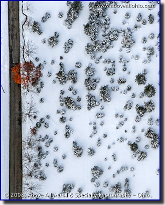
December 9-15, 2013 "Standing Out from the Crowd" There is always one guy that doesn't get the memo - in this case, all of the trees except for one have either dropped their leaves or are covered in snow. The lone tree that dared to be different stands out nicely as it hangs on to its fall foliage in this winter aerial photo from a few years ago (2008 to be exact...). Sometimes we get so caught up in our busy flight schedules that we forget to look outside and take in the view. (OK, not very often, but it does happen!) As evidenced by the fact that this photo was taken looking almost straight down, sometimes the best views are those that are right under our noses. To view a larger version of this photo, click on it or click this direct link. |
|
December 2-8, 2013
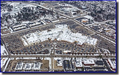
"Let the Shopping Begin" Snow and freezing temperatures couldn't keep "Black Friday" shoppers from packing the parking lot of the Summit Park Mall in Fairlawn, Ohio (just north of Akron), last week. This aerial photo of the mall was taken just after noon on what has become the busiest shopping day of the year. Quite often, the owners and property managers of shopping malls request aerial photos of their malls during the weekend after Thanksgiving so that they can show off their full parking lots to potential tenants and other investors. To view a larger version of this photo, click on it or click this direct link. |
|
November 25 - December 1, 2013
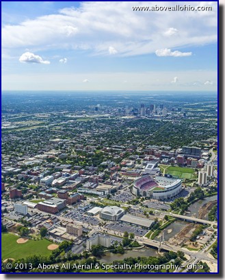
"Break Time" Thanksgiving offers a nice break before final exams at many colleges and universities throughout the U.S. (Of course, it also kicks off a very busy holiday season for many people...) This wide angle view of The Ohio State University in Columbus, Ohio, was taken on a nice summer day earlier this year. The skyline of downtown Columbus can also be seen in the distance on this remarkably clear day. We here at Above All - Ohio are thankful for many things this year - clear days like this one, great customers who kept us busy all year, our health, and people like Air Traffic Controllers and mechanics who keep us safe while flying! We hope you have a great Thanksgiving and holiday season - and we hope you take time to reflect on what you are thankful for this time of year. To view a larger version of this photo, click on it or click this direct link. |
|
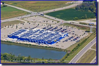
November 18-24, 2013 "Greenish Blue" The IKEA Group of companies, owned by a foundation in the Netherlands, promotes sustainability, philanthropy, and affordability in their corporate culture. One example of their "Planet Positive" strategy is their investment in solar power for their marquee blue retail stores. IKEA currently has 49 retail stores in North America. As can be seen in this shallow angle oblique aerial photo of their store near Cincinnati, Ohio, virtually every possible square foot of the roof is covered by solar panels to help with their goal of "going green" and becoming less dependant on fossil fuel energy. To view a larger version of this photo, click on it or click this direct link. |
|
November 11-17, 2013
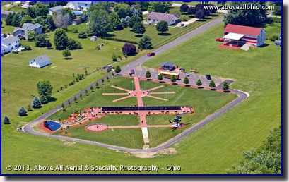
"Thank You, Veterans!" This aerial view of the Ohio Veterans' Memorial Park in Clinton, Ohio, was taken from a helicopter earlier this year. The park has a Vietnam Veterans' Memorial Wall, a POW/MIA Refelction Pond, a Cobra AH-1F helicopter display (which will one day be joined by a Huey medical helicopter), "Gold Star" statues honoring both mothers and fathers who lost children defending our freedoms, and several other monuments. Freedom is not free. Please take a moment to thank a veteran, not only on Veteran's Day, but every day... To view a larger version of this photo, click on it or click this direct link. |
|
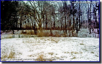
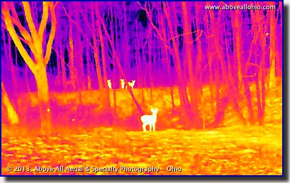
November 4-10, 2013 "Can You See the Whole Picture?" The leaves are quickly falling from the trees here in the northern part of the United States. Soon, winter will arrive and it will be the perfect time to do deer (or other wildlife) surveys. When the leaves and tall grasses disappear for the winter, so do the hiding places for many animals, including deer. Many land owners, municipalities, counties, private developers, and others want to know how many deer are on their property or within their boundaries to assess risk factors such as the effect on motorists or the ecosystem's food supply. Despite the lack of camouflage, these ground-based photos show just how difficult it is to spot a deer in the woods in visible light and just how easy it is to spot them in infrared wavelengths. Aerial infrared surveys are a cost effective way to quickly acquire wildlife counts in large areas and Above All - Ohio is one of the few companies in the nation that can complete them 100% in-house. We have our own aircraft, our own high-resolution infrared camera, our own pilots, and our own certified thermographer. With no need to outsource any part of the job, we can offer very competitive rates and 100% ownership of the project from start to finish. For more on this specialty service, please see the wildlife page in the thermography section of our web site.
To view larger versions of these photos, click on them or click these links:
|
|
October 28 - November 3, 2013
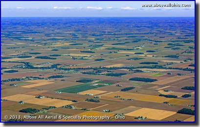
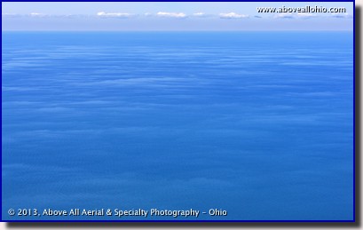
"Geographic Similarity" It occurred to us while flying over the fertile farmland of northwestern Ohio that the geography there was nearly as perfectly flat as water... A flight that took us out a little ways out over Lake Erie a few days later confirmed our observation. What do you think? Aside from the colors and a little bit of texture given to the farmland by areas of trees, the two ares are almost equally flat. (In case you noticed, yes, the sky and clouds are identical in both photos. We copied them from one photo and inserted them into the other in order to make the photos even more similar...)
To view larger versions of these photos, click on them or click these links:
|
|
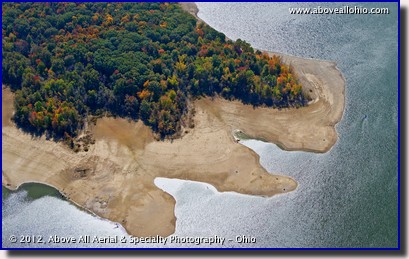
October 21-27, 2013 "Receding Shore Line" The heavy rains during the spring of 2012 were not enough to keep Ohio's lakes and reservoirs full throughout the long summer. This aerial view of Berlin Lake taken in 2012 around this time near Deerfield, Ohio, shows a wide shoreline between the fall colored trees and the water due to lower than normal water levels. Normally, the surface area of the lake covers 3,590 acres of the 8,518 acre wildlife area in northeast ohio. To view a larger version of this photo, click on it or click this direct link. |
|
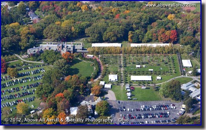
October 14-20, 2013 "Stan Hywet Hall" Fall colors were nearing their peak last year about this time as can be seen in this aerial photo of Stan Hywet Hall & Gardens, in Akron, Ohio. F. A. Seiberling -- the founder of the Goodyear Tire and Rubber Company (whose headquarters are also located in Akron) -- built this estate between 1912 and 1915. Many people believe "Stan Hywet" was the name of the owner, builder, or architect. However, "Stan Hywet" actually just means "stone quarry" in Old English dialect. As can be seen in this aerial view, the parking lots were packed for some kind of special fall event held at the estate around this time last year. (If you happen know what the event was, please let us know...) To view a larger version of this photo, click on it or click this direct link. |
|
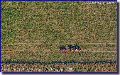
October 7-13, 2013 "Speaking of Pumpkins..." Here we see some farm hands picking up long rows of pumpkins from high above. Unlike the typical "u-pick" pumpkin patches that most of us have wandered around in search of the perfect pumpkin, when farms like this one near Fremont, Ohio, sell tons of pumpkins to large customers, the harvest needs to be a little more organized for maximum efficiency. First, workers walk down the rows and cut the pumpkins from the vine. Next, they roll the good ones to the edge of strategically placed drive lanes in the field. Finally, tractors pulling trailers of large bins drive along the row and the workers pick up the pumpkins. Pumpkins that are not fit for sale are left in the field - they will be broken up and allowed to compost. This environmentally-friendly process allows imperfect pumpkins to serve as fertilizer for future crops. To view a larger version of this photo, click on it or click this direct link. |
|
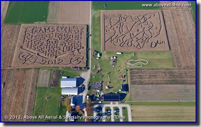
September 30 - October 6, 2013 "Fall Fun" It's that time of year again - the time when our thoughts turn to pumpkins, apple cider, colorful leaves, and corn mazes! This aerial photo is of the two corn mazes at Ramseyer Farms, located between Cleveland and Columbus, Ohio, near Wooster. (Note: None of the aerial photos on their web site were taken by us.) This photo was taken last fall - the maze on the left (called the "Mystery Maze") changes each year while the Ohio maze on the right remains the same. The farm has become an annual must-go destination for families all over Ohio. One low priced admission gets you access to both corn mazes (plus a mini-maze that the youngest guests will enjoy), a hayride, and numerous other fall-themed play areas and activities appropriate for all ages. To view a larger version of this photo, click on it or click this direct link. |
|
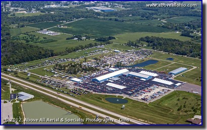
September 23-29, 2013 "Huge Auction" Each Labor Day weekend, car enthusiasts gather at the Auburn (Indiana) Auction Park to bid on cars and parts and anything else automotive- related. Billed as "the largest purpose-built, dedicated automotive auction facility in the world," the park covers 235 acres. This wide angle oblique aerial view of the park was taken during the 2012 event. More information on the park and the event can be found on the Auctions America web site. (Note: You may see another aerial photo of the facility on their web site. It is not ours...) To view a larger version of this photo, click on it or click this direct link. |
|
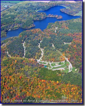
September 16-22, 2013 "Stunning Fall Colors" Autumn, 2012, was stunning. The fall colors were bright and beautiful and there were many days with perfect weather for aerial photography. This high oblique view of Findley State Park (near Wellington) was taken in early October, prior to what was regarded to as the "peak" fall color period in northern Ohio. Visible in this view is the main campground at the park and Findley Lake, which is reflecting the deep blue sky color (the color was not altered or artifically enhanced in this photo!). Schedule your fall aerials today soon to make sure we can get them during at or near the peak color times! To view a larger version of this photo, click on it or click this direct link. |
|
September 9-15, 2013
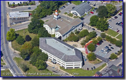
"Decked Out" The front lawn of the Lawrence County Courthouse in New Castle, Pennsylvania, is surrounded by American flags for Patriot Day, September 11. To view a larger version of this photo, click on it or click this direct link. |
|
September 2-8, 2013
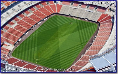
"Field Prep" The new college football season kicked off last weekend, and this week, the NFL season begins. This low and close aerial view looking into Cleveland Browns Stadium (which is now known as FirstEnergy Satidum) shows the mowing pattern cut into the field and a tractor in the early stages of marking the lines. This type of view is currently only possible from a helicopter. Although helicopters cost more to operate than airplanes, the view is often more dramatic and "sexy" than the views we see from an airplane making them well worth the premium in some situations. On a side note -- soon, we may be able to capture views such as this from remote controlled helicopters ("drones," "UAV's," "quad-copters," "hexa-copters," etc.). However, please note that commercial operation of unmanned aircraft is currently illegal at ANY altitude. When the Federal Aviation Administartion finalizes the rules and sets forth the training and operating requirments of those vehicles, we will be ready to provide that service safely, legally, and with proper insurance. However, anyone doing providing that service for hire currently is operating illegally and without insurance. If you hire someone to take photos for you via remote controlled aircraft, you are taking a huge liability risk... (Here is an article from the CBC News web site which mentions a few recent drone photography accidents.) To view a larger version of this photo, click on it or click this direct link. |
|
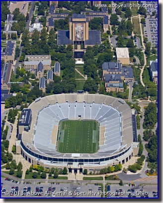
August 26 - September 1, 2013 "College Football Kickoff (It's Good!)" This week we are celebrating the return of college football. It's no secret that we here at Above All - Ohio are huge Ohio State Buckeye fans, but we thought we'd do something a little different this year and feature this cool view of another college sports icon - Notre Dame Stadium. The campus of Notre Dame is in South Bend, Indiana, near the southern end of Lake Michigan. Campus landmarks include the shiny Golden Dome of the Main Administration Building (which is not shown here, but was visible from MANY miles away as we approached the campus!) and the large mural depicting the resurection of Jesus entitled The Word of Life by Millard Sheets. Of course, most people don't know the mural by its proper name -- due to its alignment with the end zone of the football stadium and the depiction of Jesus with His arms stretched towards heaven, most people refer to the mural as "Touchdown Jesus." To view a larger version of this photo, click on it or click this direct link. |
|
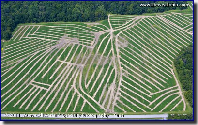
August 19-25, 2013 "Strange Farmland Patterns" The unusual, almost "herringbone" pattern seen in this field is not the result of an artist with a grand vision, a crazy urban planner, or even aliens from outer space. These lines show where underground drainage tile has recently been placed. Ohio farmers routinely dig trenches and bury perforated plastic tile several feet underground to help excess water drain from their fields. The numerous long, nearly parallel lines usually lead back to a larger mainline which allows the water to flow out of the field and into a man-made ditch, retention pond, or natural waterway. If the farmers did not do this, water from heavy rains would just sit on top of flat, saturated fields and drown the crops before it had a chance to soak in naturally. To view a larger version of this photo, click on it or click this direct link. |
|
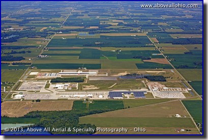
August 12-18, 2013 "Holiday City Expansion" Holiday City is a small town in the extreme northwestern corner of Ohio. It is located off of Exit 13 of the Ohio Turnpike, just 13 miles east of the Indiana border and less than 7 miles south of the Michigan border. As can be seen in this wide angle aerial view, most of the land in this rural tri-state region is flat farmland. However, a large parcel of that land is currently under development northeast of town. With room for expansion and nearby access to both the turnpike (which is not visible in this photo, but is located just below the bottom edge) and a major railroad route (which is visible as a diagonal line coming from the lower left corner), this project is well suited for the warehouses and distribution centers that are currently under construction. To view a larger version of this photo, click on it or click this direct link. |
|
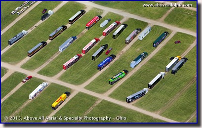
August 5-11, 2013 "Race Weekend Begins" This was the scene at Mid-Ohio Sports Car Course near Lexington, Ohio, early last week. These beautiful, brightly colored semi-truck transporters belong to the teams that participate on the Izod IndyCar Series racing circuit. Because space in the paddock area (the garage area, where teams prepare -- and repair! -- their cars) is very tight, getting these mobile work centers into place is a carefully orchestrated event. One by one, the teams' other talented drivers will move from this staging area into their assigned parking places behind the pits. Congratulations to popular driver Charlie Kimball for driving the number 83 car to victory lane in this year's race at Mid-Ohio. Charlie has Type 1 diabetes, but refused to let that condition keep him from his dream of being an IndyCar winner! To view a larger version of this photo, click on it or click this direct link. |
|
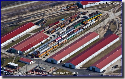
July 29 - August 4, 2013 "Best. Train. Museum. Ever." No, that's not the official motto of the Illinois Railway Museum, that's just what one very excited 2-year old boy declared after visiting a few years ago. The 166-foot long, bright orange-yellow Union Pacific Railroad #18 engine (seen here to the lower-left of center) was his favorite piece. The museum is located in Union, IL, which is about 60 miles northwest of downtown Chicago. It has hundreds of static displays and several operating trains that take visitors for short rides. The distinctive red-roofed barns house many of the older, more fragile cars and engines in their collection. If you plan to visit the museum, plan to spend (at least) an entire day! Kids of all ages will be fascinated not only by the sheer number of pieces in the collection, but also by ability to get up close to some very unusual and rarely seen types of rail cars and engines. Though this location is a little farther from home than we normally fly, we were able to swing by last year when one of our clients had multiple sites for us. As we often mention, when we have a lot of sites to string together, we can be very efficient and can provide our services affordably well outside of Ohio's borders. To view a larger version of this photo, click on it or click this direct link. |
|
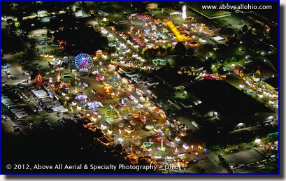
July 22-28, 2013 "Fair Time!" The Ohio State Fair starts this week - on Wednesday, July 24. This night-time aerial photo of the rides along the fair's midway was taken on the last night of the fair last year. This year's fair wraps up on Sunday, August 4. Night time aerial photography is tricky - we don't have the luxury of using tri-pods and long exposures to capture specatacular views like this. "HDR" images made from multiple exposures are not an option either - when moving in excess of 100 mph, even a fraction of a second between exposures means the camera has moved too far to get good results from blending the images. Fortunately, Above All - Ohio has the equipment and experience and has developed techniques needed to deliver spectacular views, no matter what time we take the photos. If you have a need for night time or other specialty aerial (or ground-based...) photography, please give us a call! We'll be happy to discuss your projects and we look forward to delivering beautiful images to you! To view a larger version of this photo, click on it or click this direct link. |
|
July 15-21, 2013
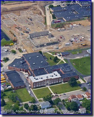
"Old School and New School" This week's aerial photo features a common site around Ohio (and, we assume...) many other parts of the country: a new school under construction. The construction industry (like most others) has been hit hard by the recession in recent years. Large projects have attracted many more bidders than in the past as companies sought to keep their workers working, even if it meant lower profits or, in extreme cases, just breaking even. While not a particularly good situation for the contractors, the extra competition helped keep bids low and made it a good time for budget-conscious school districts to look at replacing their aging and energy-inefficient buildings. Willard City Schools (in north central Ohio), was just one district in Ohio where voters seized the opportunity and approved the construction of a new high school. The existing school is in the foreground of this photo. In the upper right corner of this aerial portrait, behind the construction site, part of the Willard Jr. High School is visible. To view a larger version of this photo, click on it or click this direct link. |
|
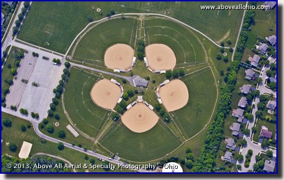
July 8-14, 2013 "All-Star Baseball Fields" Next week, on July 16, 2013, players from all over Major League Baseball will be participating in the annual All-Star Game at Citi Field (home of the New York Mets) in New York, NY. When we flew over this arrangement of baseball fields in Avery Park near Dublin, Ohio, we thought it was the perfect subject for this week's featured stock photo. We have a very wide variety of stock photos in our library. As we fly from job to job, we are constantly on the lookout for interesting scenes and landmarks. We started this "Stock Photo of the Week" feature on our web site to showcase some of them, but we can not possibly show them all. If there is anything in particular you are looking for, please let us know. We will be happy to search our archives for something that will work for you! All of our stock photos are geo-coded for quickly locating them via specified latitude and longitude. To view a larger version of this photo, click on it or click this direct link. |
|
July 1-7, 2013
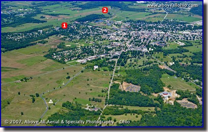
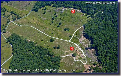
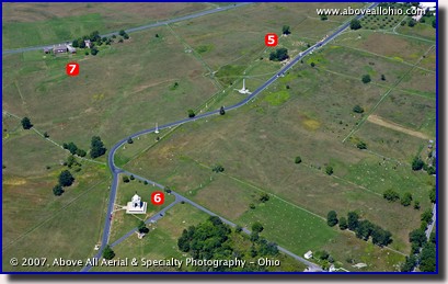
"The Battle of Gettysburg" July 1 marks the 150th anniversary of the start of the Battle of Gettysburg, which is widely held as the turning point of the Civil War. Out of respect and honor for those that fought and died there, here are some photos we took of the battlefield back in 2007... The first view shows where the battle started - to the west of the town of Gettysburg where Confederate troops advanced on McPherson Ridge (1) about 8:00 AM on July 1, 1863. The Union army held the line from here to Oak Ridge (2) most of the day, before falling back to the east side of town around 3:30 in the afternoon. On July 2, 1863, the battle had spread to the south side of town. Confederate troops were advancing on Little Round Top (3) which was lightly defended until General Meade was alerted by his chief engineer of the threat. The rocky area below (southwest of...) Little Round Top is known as Devil's Den (4). On July 3, 1863, in what is known as the "High Water Mark" of the battle, about 7,000 Union troops stationed around the "Copse of Trees" (5) held off Pickett's Charge - a 12,000-troop strong offensive assault against the Federal center. This was the climax of the battle and the Union army held strong. Lee's army began retreating on July 4, 1863. The other items of interest labeled in the third photo are The Pennsylvania Memorial (6) and Codori Farm (7) which was the center of Pickett's Charge and is a landmark that identifies the central point of the battlefield. A wide angle aerial view of the entire battlefield can be seen in our 2007 Stock Photo of the Week Gallery. The National Park Service's offical map of the battlefield can be downloaded here or from our site. To view a larger version of any photo, click on it or use these direct links: Photo 1 | Photo 2 | Photo 3 |
|
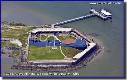
June 24-30, 2013 "Where the Civil War Began" Fort Sumter National Monument is located in Charleston Harbor, South Carolina. On April 12, 1861, Confederate forces opened fire on this fort and the Civil War began. Artillary guns bombarded the Federal fort for 34 straight hours until the fort was surrendered and evacuated. The fort is accessible only by boat. If you are lucky enough to have your own boat in the area, you can visit the fort free of charge during normal hours. Otherwise, you must purchase tickets for the ferry seen in this photo. The ferry is run by a private company, under authorization of the National Park Service. Regarding the array of flags seen in this aerial view of the island, the National Park Service web page about Fort Sumter says: "Besides the 50-star United States flag, five replicas of historic flags regularly fly over Fort Sumter. These represent a timeline of Civil War flags at the fort from 1861-1865." To view a larger version of this photo, click on it or click this direct link. |
|
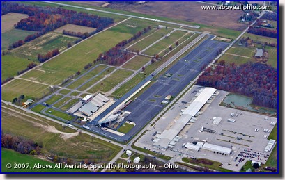
June 17-23, 2013 "Celebrating 50 Years" All is quiet at the Summit Motorsports Park near Norwalk, Ohio, in this late fall aerial view. However, during the summer, the dragstrip is busy with exciting racing events. The track is currently celebrating its 50th year in operation in Norwalk. Coming soon are the Summit Racing NHRA Nationals which will take place July 4th through the 7th. The on-track "fireworks" at this event are sure to be spectacular, but if that's not enough for you and your family, the track will put on an actual fireworks show on Friday night, July 5th. The Norwalk / Huron County airport is visible just to the north of the dragway. Pilots are cautioned on aeronautical charts not to mistake the drag strip for a runway. To view a larger version of this photo, click on it or click this direct link. |
|
June 10-16, 2013
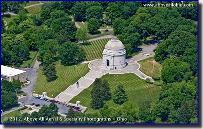
"McKinley Monument" The marble and granite McKinley Monument in Canton, Ohio, is the final resting place of William McKinley, the 25th President of the United States, and his family. More than just a memorial, this facility offers many educational programs for school groups including a 65-seat planetarium and a hands-on interactive science center. The museum is also available for event rental which can include guided tours of the historical area around the museum. The William McKinley Presidential Library & Museum is located just off of Interstate 77 on the northwest side of downtown Canton. To view a larger version of this photo, click on it or click this direct link. |
|
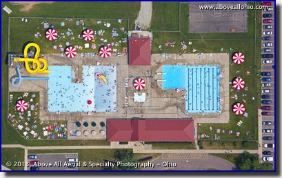
June 3-9, 2013 "Peppermints by the Pool?" School is out and summer is almost here! Soon kids (and adults!) will be packing pools like this one - the Hiawatha Park and Community Pool in Mount Vernon, Ohio - to beat the summer heat. The colorful towels, slides, and umbrellas caught our eye while we were flying by so we circled to take a few photos. However, the umbrellas reminded us of peppermint candies in this nearly vertical view so we thought this made the most interesting shot. Although we can provide true vertical imagery and aerial surveys which can be used in engineering applications, sometimes our customers just want something that appears to be looking straight down. Though it won't fool an engineer or a CAD program, a "near vertical" image such as this is a cost effective way to get the top-down view. Let us know what you need and see what we can do for you! To view a larger version of this photo, click on it or click this direct link. |
|
May 27 - June 2, 2013
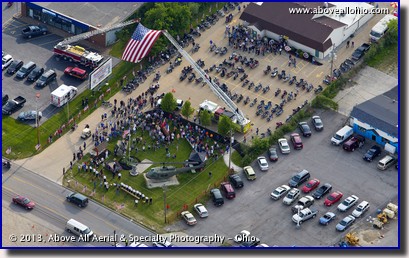
"Wounded Warrior" This Memorial Day, as always, we pause to remember those who gave the ultimate sacrifice for our freedom. This photo honors another kind of sacrifice. The event shown here was the unveiling of Ohio's first Wounded Warrior statue at the Medina (Ohio) VFW post. The event was the culmination of a motorcycle "poker run" fundraiser. More about the event (and another photo) can be found on The Post Newspapers' web site. The Wounded Warrior Project's purpose is to raise awareness of and to raise money to support injured service members. Please consider making a donation to this worthy project. To view a larger version of this photo, click on it or click this direct link. |
|
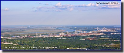
May 20-26, 2013 "Savannah Panorama" Although the downtown area is not the main focus of this photo, we're going to end our run of city views with this distinctive panoramic view of Savannah, Georgia. The historic downtown area is (barely) visible at the extreme right edge of this photo. The numerous cranes and colorful shipping containers along the Savannah River are indicators of the massive shipping operations that go on here. Huge ships come to this port from 150 different countries around the world due to Savannah's proximity to a large percentage of the U.S. population. Access to major highways and railways is easy from Savannah, which is crucial for both the collection and the distribution of goods. According to real estate giant CBRE, 44.1% of the traffic here is imports and 55.9% is exports. They also state that 88% of the cargo moving through the port are containers. Containers are metal boxes that can be stacked easily, then unloaded and placed directly onto truck trailer frames or rail cars which makes inter-modal transfers easy and efficient. For the record, we were in this area due to a huge project that we had entailing about 50 sites throughout the country. We worked under a tight deadline but we were able to deliver quality photos of all sites on time and on budget. Please give us a call if you have large projects - we have the experience and resources to take care of all of your sites, no matter where they are! To view a larger version of this photo, click on it or click this direct link. |
|
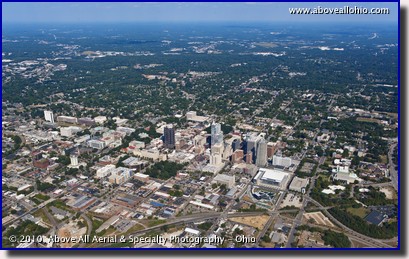
May 13-19, 2013 "Downtown Raleigh, North Carolina" Getting a little farther away from home, this wide angle aerial photo features the downtown area of Raleigh, NC. Raleigh is a city that has invested in itself and is now reaping the benefits of that investment. The city of Raleigh's offical web site boasts that Raleigh is ranked 10th on a list of cities deemed most prosperous for business by MarketWatch. Though not located in Raleigh itself, Research Triangle Park is just one example of how the vision and cooperation of area economic developers came together to make this region a leader in research and technology. The "prominent high-tech research and development center" (as described by Wikipedia) is located between Raleigh and the nearby cities of Durham and Chapel Hill. To view a larger version of this photo, click on it or click this direct link. |
|
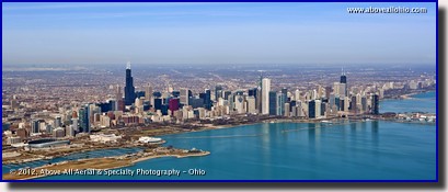
May 6-12, 2013 "Downtown Chicago, Illinois" Continuing west from last week's featured city of Toledo, we go across the southern border of Michigan / northern border of Indiana, swing around the south shore of Lake Michigan, and come upon this amazing skyline. This aerial panoramic view of Chicago, Illinois, was taken in early spring on a beautifully clear day with nearly unlimited visibility. The long, skinny light-colored area near the horizon on the left edge of the photo is Chicago's O'Hare airport which is about 16 miles from downtown. Closer to and south of downtown, near the left edge of the photo, Soldier Field (home of the Chicago bears football team) is visible. Following the very blue waters of Lake Michigan north about 2 miles, part of Chicago's famous Navy Pier can be seen at the right edge of the photo. To view a larger version of this photo, click on it or click this direct link. |
|
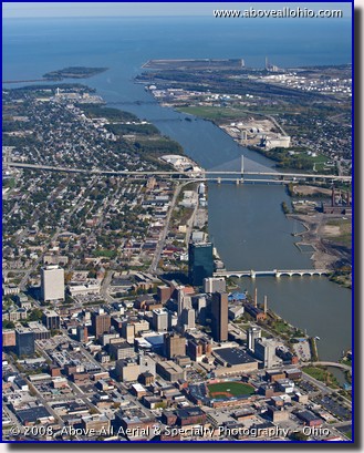
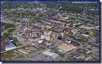
April 29 - May 5, 2013 "Downtown Toledo, Ohio" Last week, we featured a view of Youngstown, Ohio, in northeastern Ohio. This week, we head a little bit north and then west to follow the shoreline of Lake Erie all the way to Toledo in the northwestern corner of the state. In this portrait-oriented aerial view of Toledo, we can see the Maumee River passing downtown, heading north to Lake Erie. On its way, it passes under the recently re-constructed Cherry Street drawbridge and the distinctive Veterans' Glass City Skyway suspension bridge which carries Interstate 280 across the river. The tall, dark building on the west end (left side) of the Cherry Street bridge is known as "Fifth Third Center at One SeaGate." It is the tallest building in Toledo. The building was previously featured as a "Stock Photo of the Week" back in 2011. On the south side of downtown, it is easy to pick out Fifth Third Field, home of the Toledo Mud Hens minor league baseball team. To view a larger version of this photo, click on it or click this direct link. |
|
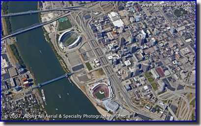
April 22-28, 2013 "Downtown Youngstown, Ohio" Youngstown, Ohio, is located in northeastern Ohio and is just a short flight from our home airport in Medina. This wide angle aerial view was captured on a beautiful fall day in October, 2007. According to the city's official web site, Youngstown was incorporated in 1867. The city is probably most known locally for its large steel industry and is currently enjoying a rebound from the recession that hit many industrial cities very hard recently. Visible in the upper part of this photo, just right of center, is the campus of Youngstown State University. The University's athletic facilities - the towering stands of the football stadium (Stambaugh Stadium), the bright green rectangle of tennis courts, and the red oval running track - are the easiest landmarks to spot in this aerial photo. To view a larger version of this photo, click on it or click this direct link. |
|
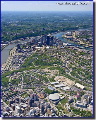
April 15-21, 2013 "Downtown Cincinnati, Ohio" We don't get to downtown Cincinnati, Ohio, very often, but we do get there. (Cincinnati is actually closer to our Indianapolis office than it is to our Ohio office, and they serve that area more frequently). This view was taken from a very high altitude - about 10,000 feet (nearly 2 miles!) above the city. Still, thanks in no small part to our professional Canon cameras and lenses, one can still clearly read the word "Bengals" in both end zones at Paul Brown Stadium in the full size version of this photo. Also clearly visible next to the Ohio River, are the red seats of Great American Ballpark, home of the Cincinnati Reds baseball team. To view a larger version of this photo, click on it or click this direct link. |
|
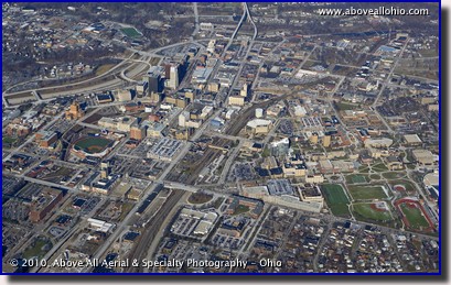
April 8-14, 2013 "Downtown Pittsburgh, Pennsylvania" Another downtown area that we visit regularly is Pittsburgh, Pennsylvania. In the foreground of this portrait-oriented aerial view of Pittsburgh is part of the University of Pittsburgh. The round building just right of center near the bottom of this photo is the Petersen Events Center. The University's men's and women's basketball teams play here, of course, but the facility also plays host to a variety of concerts, conventions, and other events. In the distance, again to the right of center, Heinz Field (home of the Steelers) and PNC Park (home of the Pirates) can be seen along the river. To view a larger version of this photo, click on it or click this direct link. |
|
April 1-7, 2013 "Downtown Akron, Ohio" It seems like we have lots of photos of Cleveland and Columbus in our gallery, so for the next few weeks, we'll feature some other "downtowns" of areas that we serve. First up is downtown Akron, Ohio. This wide-angle, high oblique aerial photo was taken on a sunny January day. The low winter sun creates shadows that look more like late day shadows, except that high-noon winter shadows point north. These can be seen in the upper left part of the image. In the middle of the photo is the Quaker Square area and to the right, the frozen campus and sports fields of the University of Akron are visible. To view a larger version of this photo, click on it or click this direct link. |
|
March 25-31, 2013
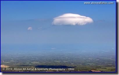
"Flying Easter Bunny?" We spend a lot of time up in the air looking down at the ground, but sometimes it pays to look at the other parts of the sky and see who's flying around with us... We thought this lonely cloud sort of looked like an Easter Bunny, running or leaping through the air so fast that his ears are laid down flat on his back. As for the little cloud behind him, well, we're just going to say that's a piece of his cotton tail that fell off because he was running to the next house so fast... To view a larger version of this photo, click on it or click this direct link. |
|
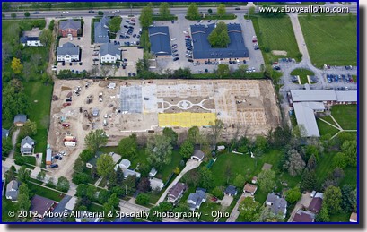
March 18-24, 2013 "Start of the Season" Spring is here and we all know what that means - construction season will soon be in full swing! This oblique view of a construction site is an example of what we provide to contractors, project owners, investors, or others with a financial interest in large projects. Having a neutral third-party provide documentation of construction progress allows all parties involved to see that money is being spent on work as it is intended. Sometimes, contractors use our periodic aerials to spot problems, take inventory of tools and supplies that are on the site, or just to document the job for posterity (after all, they will only ever have ONE chance per project to get views like these...). We typically provide our customers with 8 to 12 different views after each trip, but sometimes more are required to cover all of the site. (Unlike some companies, we do not charge per photo - we deliver as many photos as are needed to completely document the site, but the price doesn't change.) We have provided progression aerials on a full range of schedules customized to fit our clients' needs. We have provided weekly, twice per month, monthly, quarterly, annual, and irregular "on-demand" services. Please contact us if we can be of service on your project! To view a larger version of this photo, click on it or click this direct link. |
|
March 11-17, 2013
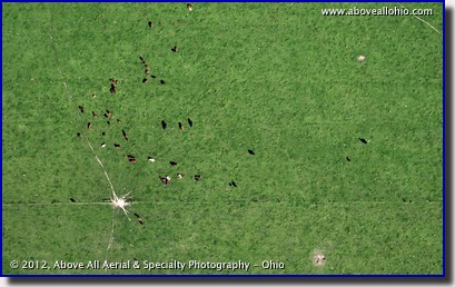
"Green, Green Field" In honor of St. Patrick's Day this week, we decided to go back to featuring a photo with a lot of green. We searched the archives and found this photo - perhaps the "greenest" photo we have! This nearly vertical aerial photo is of a field of cows feeding in a pasture. (We think it looks like a flag, especially with the paths to the feeding trough making a kind of a star pattern. What do you think?) This view makes it easy to count large animals - cows in this case - and it is similar to how we would count wildlife. However, counting deer in the woods is not this easy -- deer are very well camoflagued so our regular aerial photo maps would be of little (or no...) use for determining the size of the herd (even at very high 3-inch resolution). Fortunately, we have a better way to accomplish that task -- aerial infrared imaging. Deer generate heat, and hiding from our FLIR infrared camera is much, much more difficult! We are wrapping up this season's deer surveys (they are best done in the winter), but stay tuned if you are curious - we will feature a sample infrared animal survey image on this page in the fall. To view a larger version of this photo, click on it or click this direct link. |
|
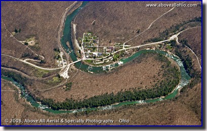
March 4-10, 2013 "White Water River" After a featuring photos showing some green grass for the past couple of weeks, we thought we'd go back to an aerial view that shows what the landscape looks like on a more typical early spring day here in the northern states. This aerial photo shows the small city of Ohiopyle, Pennsylvania, nestled in a bend of the Youghiogheny River. As can be seen, there are some nice white water rapids in the river in this area making it a popular destination for adventure seekers. One popular local business offering white water rafting trips is White Water Adventures. White Water Adventures is located within the Ohiopyle State Park and offers both family friendly "Class I and II" rafting trips as well as "Class III, IV, and V" trips for the more daring and experienced rafters. To view a larger version of this photo, click on it or click this direct link. |
|
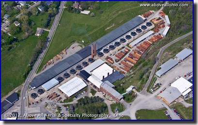
February 25 - March 3, 2013 "Brick Factory" In our attempt to help chase away the winter blues, we have chosen another photo showing lots of green grass. This photo was taken last April after a very mild winter - things are not normally this green that early in the spring here in northern Ohio. This steep oblique aerial photo is of The Belden Brick Company in Sugarcreek, Ohio (south of Canton, in Ohio's Amish Country). The original twin smoke stacks are still used and in this photo, you can see the name of original company - "Finzer Bros." built into one of them. The stacks appear to have been shortened at some point in time, however, as the top of the "F" in "Finzer" is missing. This factory was originally built and owned by a family of Swiss immigrants in the mid-1800's according to a brief history of the plant found here: Finzer Brothers Clay Company (The writer of the article incorrectly states that the name of the town is two words - "Sugar Creek" - but as far as we know, the rest of the article is accurate.) To view a larger version of this photo, click on it or click this direct link. |
|
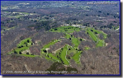
February 18-24, 2013 "Oasis" It's not quite golfing weather yet, but we thought this view of a nice green course would help ease the winter blues. This is Sleepy Hollow Golf Course, located in Brecksville, Ohio. (Brecksville is a southeastern suburb of Cleveland.) Sleepy Hollow is part of the Cleveland Metroparks system and is regarded as one of Ohio's most beautiful and challenging courses. In the full size version of this photo, a few early season golfers can be seen enjoying the course. Judging by this photo, taken in early spring a few years ago, the parks know how to take care of the grass. The trees are bare and the surrounding grassy areas are still brown and dormant after winter, but the grass on the course is beautiful and green. It really stands out from the air. To view a larger version of this photo, click on it or click this direct link. |
|
February 11-17, 2013
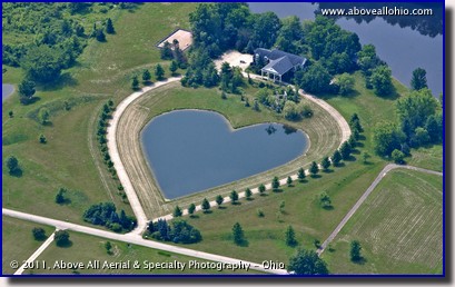
"What's Not to Love?" This giant Valentine is located between Strongsville and Columbia Station, Ohio (just south of Cleveland). We estimate it to be over 350' long and over 300' wide. We don't know if it was actually a Valentine's gift or not, but if it was, one question we'd really like to know the answer to is how does one top something like this the next year? To view a larger version of this photo, click on it or click this direct link. |
|
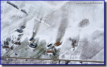
February 4-10, 2013 "Visual Aerodynamics Lesson" The snow patterns seen in this photo are a good visual example of how wind moves around buildings and through trees. Solid objects (i.e., the buildings in the center of this photo) deflect the air. This pushes the snow that is being carried in the wind to the sides of the buildings. The buildings protect a good-sized area behind them (the area protected is proportional to the speed of the wind). When the wind hits an obstacle that is not solid (like a bare tree), the air flow is diverted to some extent, but the main effect is that it slows down. This can be seen in the upper left corner - the wind is slowed enough to allow the snow to drop to the ground instead of just continuing to blow across the open field. To view a larger version of this photo, click on it or click this direct link. |
|
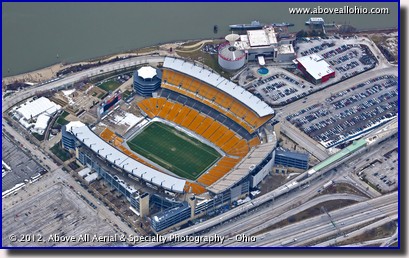
January 28 - February 3, 2013 "Frozen Ketchup?" Heinz Field Stadium in downtown Pittsburgh, PA, appears cold and deserted in this aerial photo taken last winter. The Steelers and 29 other NFL teams were "frozen out" of this weekend's big game in New Orleans between the Baltimore Ravens and the San Francisco Forty-Niners... The stadium was completed in 2001 and replaced the legendary multi-use Three Rivers Stadium as the home of the NFL's Pittsburgh Steelers. The new stadium was built right next to the old one at the location where the Allegheny and Monongahela Rivers meet to form the Ohio River. Also visible in this photo to the right of the stadium is the Carnegie Science Center. One of its exhibits - the Cold War-era USS Requin submarine - can be seen in the river. To view a larger version of this photo, click on it or click this direct link. |
|
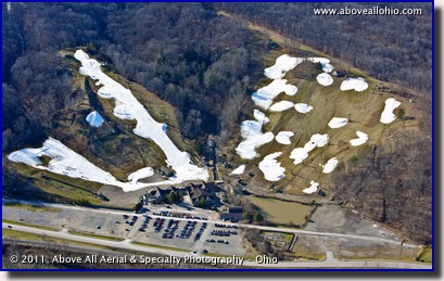
January 21-27, 2013 "Bare Slopes" Last winter's unusally mild weather was nice for most northern Ohioans, but not for those who enjoy snow skiing and certainly not for the owners and operators of ski resorts such as this one - Boston Mills Ski Resort in Peninsula, Ohio, just outside of Cleveland. The snow makers clearly could not compete with Mother Nature on these slopes. It appears that the resort gave up trying to cover the northern runs (seen on the right side of this photo). The southern runs on the left are angled in such a way that they receive less direct sunlight and were therefore more easily covered. So far this year, northern Ohio is experiencing a more typical winter with lower temperatures and more snow; we can't say that we're really thrilled about that, but it is good news for skiers and businesses that rely on them! To view a larger version of this photo, click on it or click this direct link. |
|
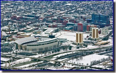
January 14-20, 2013 "Cold School" One probably doesn't need to spend a lot of time browsing our web site and our various galleries to figure out that The Ohio State University is one of our favorite places to photograph. (It is, after all, the alma mater of 100% of our full time staff...) Ohio Stadium and the twin dorm towers dominate this somewhat low-level oblique aerial winter view of the campus. Visible behind those three easily recognizable landmarks is a large part of the medical school and some of the world class hospitals that are located right on the campus. To view a larger version of this photo, click on it or click this direct link. |
|
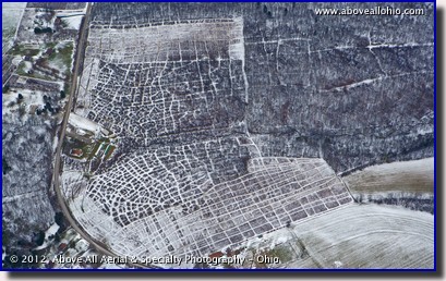
January 7-13, 2013 "Quilted Fields" Although our view out the window this time of year is somewhat mono-chromatic, winter aerials often show interesting patterns and provide views of things we can't see at any other time of the year. With the leaves gone from the trees and a light dusting of snow, paths between the trees are highlighted nicely in this aerial photo. The twists and turns of a small stream that runs through the woods can be easily seen in this photo as well. The paths and the stream would be impossible to see if the trees had their leaves. Winter also allows us to perform highly accurate infrared aerial deer surveys (and/or other game counts). Keep checking back here and on our infrared pages - we will be adding some samples and featuring a particularly interesting infrared image soon! To view a larger version of this photo, click on it or click this direct link. |
|
January 1-6, 2013
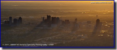
"Dawn" This panormaic view of downtown Columbus (Ohio) at sunrise was taken from the southwest side of the city, looking northeast. The yellow-orange sky takes the term "golden hour" to its most literal meaning and the long building shadows that can be seen in the thin morning mist add a nice dramatic effect to this photo. Since most of our clients are interested in the details they can see in the photos, we tend to do most of our flying during the middle of the day when the shadows are minimized. However, when the client wants images for marketing purposes, we can shoot at dawn, dusk, night, or anytime when the light will work best for their purposes. We thought a dawn photo was appropriate for the first "Stock Photo of the Week" image for the new year. We look forward to another year of helping our clients in a wide variety of ways, however - and whenever - we can! To view a larger version of this photo, click on it or click this direct link. |
|
|
||

2012 |

> 2013 < |

2014 |
|
|
||


